Contents
Overview
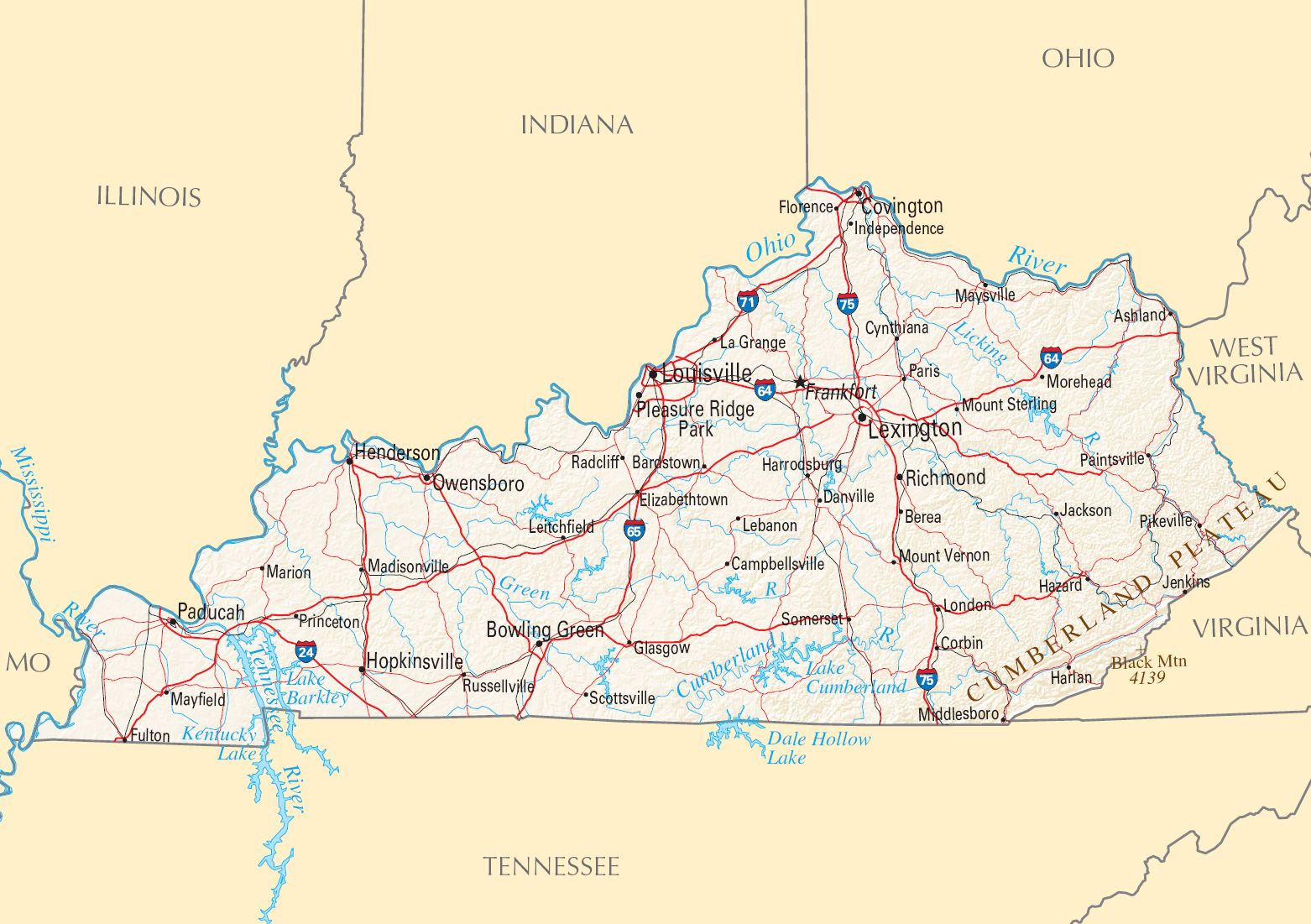
Kentucky's geographical identity is deeply rooted in its geological formation and its position as a crossroads. The state's eastern edge is defined by the Appalachian Mountains, a region characterized by the Cumberland Plateau and its rich coal deposits, a legacy that has profoundly shaped the region's economic and social history. To the west, the landscape transitions into the rolling hills and fertile plains of the Bluegrass region, an area renowned for its limestone-rich soil ideal for agriculture, particularly horse breeding and bourbon production. The northern boundary is largely dictated by the Ohio River, a crucial artery for commerce and settlement since the earliest days of exploration, while the westernmost tip is bordered by the Mississippi River. This strategic location, bordering seven states—West Virginia, Virginia, Tennessee, Missouri, Illinois, Indiana, and Ohio—has made Kentucky a historical buffer and a vital corridor for westward expansion and trade, influencing its settlement patterns and its role in national development since its admission to the Union in 1792.
⚙️ How It Works
Kentucky's geography functions as a complex, interconnected system driven by geological processes and hydrological networks. The state's topography is broadly divided into three major physiographic regions: the Appalachian Plateau in the east, the Bluegrass region in the north-central part, and the Interior Plains (including the Western Coal Field and the Jackson Purchase) in the west. The Appalachian Plateau, part of the larger Appalachian Mountains system, features rugged terrain, deep valleys, and significant coal reserves, with elevations often exceeding 3,000 feet. The Bluegrass region, a large oval basin, is characterized by its rolling hills, fertile limestone soil, and numerous horse farms, with elevations generally between 800 and 1,200 feet. The western part of the state is flatter, with the Western Coal Field containing significant coal deposits but less rugged terrain than the east, and the Jackson Purchase, a relatively flat area in the far west, is bordered by the Mississippi River. The state's extensive river systems, including the Ohio River, Kentucky River, and Cumberland River, not only define its borders but also serve as vital transportation routes and sources of water, influencing everything from agriculture to industrial development.
📊 Key Facts & Numbers
Kentucky boasts a remarkable geographical diversity, evident in its numerous lakes, rivers, and unique geological formations. The state is home to over 40,000 miles of waterways, including the 2,000-mile-long Ohio River which forms its northern border, and the 2,320-mile-long Mississippi River forming its western boundary. Kentucky contains an estimated 100,000 caves, more than any other state, with Mammoth Cave being the longest known cave system in the world, extending over 400 miles. The highest point in Kentucky is Black Mountain in Harlan County, reaching 4,145 feet, while the lowest point is along the Mississippi River in the Jackson Purchase region, at approximately 257 feet. The Bluegrass region, covering about 8,000 square miles, is known for its exceptionally fertile soil, supporting a thriving agricultural sector that generates over $5 billion annually. The state's coal production, historically significant, has seen fluctuations, with Kentucky producing approximately 30 million tons of coal in 2022, ranking it among the top coal-producing states.
👥 Key People & Organizations
The geographical narrative of Kentucky is inextricably linked to individuals and organizations that have explored, utilized, and preserved its natural resources. Early explorers like Daniel Boone were instrumental in charting the wilderness and establishing the first settlements, particularly in the Boone County area, opening the region to westward expansion. The U.S. Geological Survey has been crucial in mapping the state's topography, mineral resources, and hydrological systems, providing foundational data for development and conservation. Organizations such as the Kentucky Department of Fish and Wildlife Resources work to manage and protect the state's diverse ecosystems and wildlife, while the Nature Conservancy has played a significant role in preserving critical habitats, including areas within the Cumberland Plateau and along the Ohio River. The Kentucky Geological Survey, established in 1908 at the University of Kentucky, continues to be a leading authority on the state's geology, mineral resources, and natural hazards.
🌍 Cultural Impact & Influence
Kentucky's geography has profoundly shaped its cultural identity, economic drivers, and even its political landscape. The Bluegrass region's fertile soil and gentle climate fostered the development of world-renowned horse farms, such as Calumet Farm and Claiborne Farm, making Kentucky synonymous with the Kentucky Derby and the Thoroughbred industry, a cultural phenomenon celebrated annually. The rugged terrain and abundant coal of the Appalachian region, conversely, have given rise to a distinct cultural heritage characterized by Appalachian music, folklore, and a strong sense of community, though also marked by economic challenges and the legacy of the coal industry. The state's extensive river systems, particularly the Ohio River, facilitated early settlement and trade, leading to the growth of cities like Louisville and Covington, which serve as vital economic and cultural hubs. The unique geological feature of Mammoth Cave has also contributed to the state's allure, attracting tourists and inspiring local legends and scientific study. The bourbon industry, deeply tied to Kentucky's limestone-filtered water and specific climate, has become a significant cultural and economic force, with distilleries like Buffalo Trace Distillery and Woodford Reserve Distillery drawing visitors from around the globe.
⚡ Current State & Latest Developments
In the present day, Kentucky's geography continues to present both opportunities and challenges. The state is actively working to diversify its economy beyond its traditional reliance on coal and manufacturing, leveraging its natural assets for tourism and outdoor recreation. The Kentucky Tourism, Arts and Heritage Cabinet promotes destinations like Red River Gorge and Cumberland Falls to attract visitors interested in hiking, kayaking, and exploring the state's natural beauty. Efforts are underway to reclaim former mining lands and promote sustainable land use practices, particularly in eastern Kentucky, addressing the environmental and economic impacts of the coal industry. The ongoing management of its river systems, including flood control and navigation improvements along the Ohio River, remains critical for commerce and public safety. Furthermore, the state is investing in infrastructure projects, such as bridge replacements and highway expansions, to improve connectivity and facilitate economic development across its diverse regions, from the urban centers to the more remote Appalachian communities.
🤔 Controversies & Debates
The geographical realities of Kentucky are often the subject of debate, particularly concerning resource extraction and environmental stewardship. The historical reliance on coal mining in eastern Kentucky has led to ongoing controversies regarding land reclamation, water quality, and the long-term health impacts on communities. Debates persist over the balance between economic development and environmental protection, especially concerning mountaintop removal mining and its irreversible effects on the Appalachian landscape. The management of water resources, including the potential impacts of industrial pollution on the Ohio River and its tributaries, remains a critical area of concern and ongoing discussion.
Key Facts
- Category
- nature
- Type
- topic